 Catalogue PIGMA
/Physical oceanography/Other physical oceanographic measurements
Type of resources
Available actions
Topics
Keywords
Contact for the resource
Provided by
Years
Formats
Representation types
Update frequencies
status
Scale
Resolution
-
JRA55-do is a surface dataset for driving ocean-sea ice models and used in phase 2 of OMIP (OMIP-2). JRA55-do corrects the atmospheric reanalysis product JRA-55 (Kobayashi et al., 2015) using satellite and other atmospheric reanalysis products. The merits of JRA55-do are the high horizontal resolution (~55 km) and temporal interval (3 h). An assessment by Tsujino et al. (2020) implies that JRA55-do can suitably replace the current CORE/OMIP-1 dataset. This reanalysis of atmospheric variables is provided by the Japanese Meteorological Agency starting in the year 1958 and will be used to drive the coupled NEMO-ERSEM model in the hindcast configuration.
-

Several climate indices, regarding Atlantic Basin: - North Atlantic Oscillation - Southern Oscillation Index - Bivariate ENSO Timeseries - Tropical Northern Atlantic Index - Tropical Southern Atlantic Index - Oceanic Niño Index - Multivariate ENSO Index (MEI V2) - North Tropical Atlantic SST Index - ENSO precipitation index - Northeast Brazil Rainfall Anomaly - Solar Flux (10.7cm) - Global Mean Lan/Ocean Temperature
-
The Joint WMO-IOC Technical Commission for Oceanography and Marine Meteorology Observing Programmes Support Centre, provides technical coordination at international level for the sustained elements of the Global Ocean Observing System. The Centre monitors in real-time the status of the observing networks and provides a toolbox to evaluate their performance and optimize their implementation and data flow. Currently OceanOPS monitors the Argo profiling floats, the DBCP surface drifters, coastal and tropical moorings, ice buoys, tsunami buoys, the OceanSITES moorings time-series, the GO-SHIP hydrographic reference lines, the SOT mat/ocean ship based observations and the GLOSS sea level tide gauges. A number of other observing systems are being added gradually, including ocean gliders, polar systems, marine mammals and potentially HF radars.
-

Data and imagery from the Atlantic basin: - Climate - Cloud Profiling Radars - Air-Sea & Air-Land Fluxes - Wind Profiling Radars - Satellite - Local Weather and Climate PSL archives a wide range of data ranging from gridded climate datasets extending hundreds of years to real-time wind profiler data at a single location. The data or products derived from this data, organized by type, are available to scientists and the general public at the links in the website. The third-party data appearing on this web site may be reformatted from their original form, but not altered as to the informational content contained therein. It is provided as a public service. Further, this data does not reflect an official view or position of NOAA.
-
The Ocean Colour Climate Change Initiative project aims to: Develop and validate algorithms to meet the Ocean Colour GCOS ECV requirements for consistent, stable, error-characterized global satellite data products from multi-sensor data archives. Produce and validate, within an R&D context, the most complete and consistent possible time series of multi-sensor global satellite data products for climate research and modelling. Optimize the impact of MERIS data on climate data records. Generate complete specifications for an operational production system. Strengthen inter-disciplinary cooperation between international Earth observation, climate research and modelling communities, in pursuit of scientific excellence. The ESA OC CCI project is following a data reprocessing paradigm of regular re-processings utilising on-going research and developments in atmospheric correction, in-water algorithms, data merging techniques and bias correction. This requires flexibility and rapid turn-around of processing of extensive ocean colour datasets from a number of ESA and NASA missions to both trial new algorithms and methods and undertake the complete data set production. Read more about the Ocean Colour project on ESA's project website. https://climate.esa.int/en/projects/ocean-colour/.
-
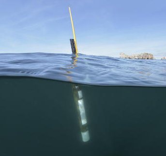
Argo is a global array of 3,000 free-drifting profiling floats that measures the temperature and salinity of the upper 2000 m of the ocean. This allows, for the first time, continuous monitoring of the temperature, salinity, and velocity of the upper ocean, with all data being relayed and made publicly available within hours after collection. The array provides 100,000 temperature/salinity profiles and velocity measurements per year distributed over the global oceans at an average of 3-degree spacing. Some floats provide additional bio-geo parameters such as oxygen or chlorophyll. All data collected by Argo floats are publically available in near real-time via the Global Data Assembly Centers (GDACs) in Brest (France) and Monterey (California) after an automated quality control (QC), and in scientifically quality controlled form, delayed mode data, via the GDACs within six months of collection.